There are road trips, and then there is this one.
The loop from Lucerne through the heart of the Swiss Alps – ticking off the Klausen, Susten, Furka, and Gotthard passes before dropping down into the palm-tree warmth of Lago Maggiore – is one of the finest drives in Europe. You get cobblestone hairpin bends, glacier-edge roads, the meadow where Switzerland was born, a James Bond film location, and a Mediterranean lake town at the end of it, all connected by some of the most extraordinary mountain scenery on the continent.
This guide covers the full route from Lucerne to Lago Maggiore with detailed breakdowns of each pass, what to stop for, how long each section takes, and every practical piece of information you need to drive it well. Bookmark it before you go.
The Route: Overview
The core loop covers roughly 300 kilometres of driving, though distances mean very little on Swiss Alpine passes – what looks like 30km on the map can take 90 minutes to drive properly, and you’ll want to stop often. Allow a minimum of two full driving days, or three if you want a night in Andermatt and time to actually breathe at Lago Maggiore.
The sequence:
- Lucerne – Klausen Pass – Andermatt (Day 1)
- Susten Pass side excursion from Andermatt, then Furka Pass – Airolo/Gotthard Pass area (Day 2)
- Gotthard Pass south into Ticino – Biasca – Bellinzona – Locarno/Lago Maggiore (Day 2-3)
The passes connect logically because they all converge around Andermatt – the mountain village in Canton Uri that sits at the intersection of eight Alpine passes and effectively acts as the hub of central Switzerland’s road network. If you’re doing this trip, Andermatt is both your most logical overnight stop and one of the most satisfying places in the country.
Before You Go: Essential Practicalities
Swiss Motorway Vignette
If you use any Swiss motorway (Autobahn) en route – which you will – you need a Swiss Motorway Vignette. It costs CHF 40 per calendar year and covers all Swiss motorways. It can be purchased online before arrival as a digital e-vignette (by far the easiest option) or as a sticker at the border or at petrol stations near entry points. Driving on a Swiss motorway without one carries a fine. Buy it before you travel.
Pass Opening Dates 2026
All four passes covered in this guide are seasonal – they close in winter and don’t reopen until spring or early summer. This is non-negotiable: check official status before you travel.
Based on typical 2026 schedules (confirmed against alpen-paesse.ch):
- Klausen Pass: Expected to open mid-May 2026 (snow clearance begins mid-April 2026)
- Gotthard Pass: Expected to open around end of May 2026
- Susten Pass: Typically opens early to mid-June; one of the last to clear
- Furka Pass: Scheduled to open 1 June 2026, weather permitting
The window when all four passes are reliably open is late June through mid-October. If you’re travelling in early June, the Gotthard and Klausen are likely open while Furka and Susten may be borderline – check individual pass status at alpen-paesse.ch the morning of your drive. They update in real time.
For October travel: Passes begin closing from the top down. Furka typically closes first (mid-October), then the others through late October. Check daily.
Fuel
Petrol stations become very scarce above 1,500m. Fill up properly in valley towns before beginning any pass climb. Key fuelling stops: Lucerne, Altdorf (foot of Klausen), Andermatt, Meiringen or Innertkirchen (before Susten), and Airolo or Biasca (south of Gotthard). Don’t rely on finding petrol on the passes themselves.
Road Rules
- Speed limits on Alpine passes are typically 50km/h through villages, 80km/h on open pass roads (though you’ll rarely want to push it)
- Uphill traffic has right of way over downhill traffic on narrow sections
- Coaches and PostBuses have priority over private vehicles – pull into passing places when you see them coming
- No towing trailers on Klausen Pass for private vehicles
- Carry a warning triangle and high-visibility vest (Swiss law)
- Check alpen-paesse.ch or the TCS Switzerland app for real-time pass status
Lucerne to Andermatt via the Klausen Pass
Distance: approximately 100km | Driving time: 2.5-3.5 hours without stops
The Klausen Pass is the opening act and, at 1,948m, perhaps the least famous of the four passes in this guide. That’s largely why it’s so good. While the Furka draws Bond fans and the Gotthard has history books written about it, the Klausen sits quietly delivering one of the most varied and genuinely surprising drives in Switzerland, with traffic that reflects its under-the-radar status.
Leave Lucerne heading south toward the A4/A14. The drive down to Altdorf (at the base of the pass, roughly 40 minutes from Lucerne) takes you past the southern end of Lake Lucerne through the Urnersee – the dramatic fjord-like arm of the lake that you may have seen from the water if you did the Lake Lucerne boat trip. From the water this section looks impossibly steep; from the road you’ll understand why.
Altdorf and Bürglen – William Tell Country
Before the climb begins, the small town of Altdorf is worth a brief stop. The famous bronze Tell Monument stands in the main square – a heroic statue of William Tell with his son at his feet, one of the most photographed Swiss landmarks. Altdorf is the centre of the William Tell legend: the story goes that Tell was forced to shoot an apple from his son’s head here in the 14th century by the Habsburg governor Gessler.
Bürglen, the village at the entrance to the Schächental valley a few minutes south of Altdorf, is considered Tell’s actual birthplace according to the tradition. The Tell Museum in the village centre houses the largest collection of objects, documents, and depictions relating to the Swiss national hero. The Klausenpassrennen – the legendary hillclimb race run between 1922 and 1934, at the time considered the toughest mountain race in Europe – also started here. From 2026, this historic event is being revived every two years with vintage cars, so if your timing is right you might catch it.
The Klausen Climb
The road up from Bürglen heads into the Schächental valley, one of the most beautiful and least-visited valleys in central Switzerland. The scale is immediately impressive – the valley walls rise steeply on both sides and the peaks above are serious Alpine terrain, not the rounded green hills of lower Switzerland.
The climb involves tight switchbacks carved into the rock face, forest sections, short tunnels, and then a sudden opening onto the Urnerboden – a 5km-long alpine plateau at around 1,400m that catches most drivers completely off guard. This is the largest alpine pasture in Switzerland, with up to 1,200 cows during summer and an alpine cheese dairy producing Urnerboden cheese. Stop, get out, and take it in. The granite peaks on the right side of the plateau are genuinely dramatic.
At the back of the plateau, what appears to be a dead end in the valley reveals itself as the final climb – 40 or so tight hairpin turns carved directly into the rock face. This section is the driving highlight of the pass. On the way up you’ll pass the Stäubifall waterfall visible across the valley (most powerful in early summer when the snowmelt is running), and the summit at 1,948m marked by a chapel and a café where you can catch your breath.
The descent toward Linthal on the Glarus side is less dramatic than the ascent, which suits the post-climb relaxation well.
From Linthal, the A3 motorway takes you west and south through the Walensee valley, then the A2 brings you south toward Flüelen and the approach to Andermatt via Göschenen and the Schöllenen Gorge. Total driving time from the Klausen summit to Andermatt: around 45-60 minutes.
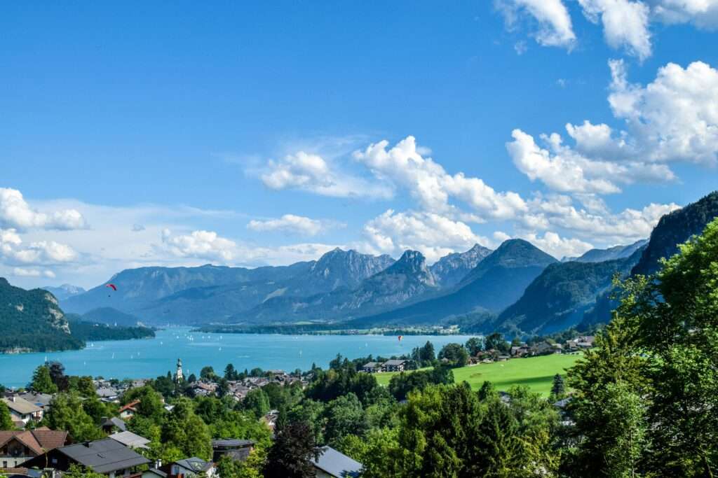
Andermatt: Your Alpine Hub
Andermatt deserves more than a fuel stop. This village in the Urseren Valley sits at 1,447m surrounded entirely by mountains and is the intersection point of eight Alpine passes – Gotthard, Furka, Oberalp, Klausen, and more. It’s been a strategic mountain crossing for centuries, and that history is still visible in the old patrician houses along the main street.
The historic Schöllenen Gorge, just north of Andermatt, is extraordinary and often missed by drivers hurrying through. The gorge is where the River Reuss carved a path through an impossibly narrow defile, making the Gotthard route viable. The Devil’s Bridge (Teufelsbrücke), an 18th-century stone bridge spanning the gorge, is one of the most dramatic pieces of infrastructure in Switzerland. There’s a car park near the gorge viewpoint – it takes about 20 minutes to walk down and back.
Andermatt itself has expanded significantly since The Chedi hotel opened in 2013 as Switzerland’s first five-star resort here, and there’s now a proper resort infrastructure alongside the old village. For an overnight stop, it’s an excellent base – compact and walkable, with good restaurants, easy access to the passes the following morning, and a genuine mountain atmosphere.
What to see in Andermatt:
- The Schöllenen Gorge and Devil’s Bridge
- The old village main street and Ursern Valley Museum
- The Four Springs Trail (Vier-Quellen-Weg) – a multi-day hiking trail that passes through Andermatt connecting the sources of the Rhine, Rhône, Reuss, and Ticino rivers. The section near the Oberalp Pass is excellent as a day walk
The Susten Pass: Switzerland’s Most Scenic Road
Distance: 45km Wassen to Innertkirchen | Driving time: 1-1.5 hours one way
The Susten Pass deserves its reputation as Switzerland’s most visually rewarding drive. Where the Furka is cinematic and famous, the Susten is technically superior and, for many experienced Alpine drivers, simply more beautiful. It’s the only major Swiss pass road built specifically for motor vehicles from the start – construction ran from 1938 to 1946, and the quality of the engineering shows in the sweeping, wide curves and excellent road surface.
From Andermatt, head north to Wassen – a village you’ll have seen from the train if you’ve done the Gotthard route, recognisable for the way the rail line spirals up through tunnels to gain altitude, crossing above the same church three times from three different directions. From Wassen, head west onto the Susten Pass road.
The Drive West to East (Wassen to Innertkirchen)
The eastern approach from Wassen climbs through the narrow Meienreuss gorge, with the SBB Gotthard railway’s switchback tunnels visible early on the climb. The road passes through a series of short tunnels cut through the granite spurs before the valley opens and the scenery begins to shift from gorge to open Alpine terrain.
The upper section is where the Susten earns its reputation. The Steingletscher viewpoint – a glacier overlook on the Bernese side of the summit – is the visual centrepiece of the whole pass. The Stein Glacier descends dramatically from the peaks above, and the Hotel Steingletscher (one of the only buildings at this altitude) offers a terrace with full glacier views. This is where you stop, get out properly, and accept that Switzerland is ridiculous.
The summit is reached through a 300m tunnel that pierces the ridgeline – a detail that adds to the engineering spectacle. On the Bernese side, the road descends in long, flowing curves toward Gadmen, with constantly changing views of glaciers, waterfalls, and alpine meadows. The village of Gadmen partway down is photogenic and has a restaurant if you want to stop. The descent into Innertkirchen takes you through forested lower valleys and over stone bridges that make the whole thing feel like the ending of a very good chapter.
The Susten is best driven west to east (Wassen to Innertkirchen) for the most rewarding ascent. Most drivers on this loop do a return trip back to Andermatt from Innertkirchen, or continue to Meiringen (a few kilometres from Innertkirchen – note this is where the fictional Sherlock Holmes supposedly died at the Reichenbach Falls) before heading back to the Gotthard corridor.
Opening: The Susten typically opens in early to mid-June and closes in late October. It is consistently one of the last Swiss passes to open due to snow depth. Check alpen-paesse.ch before going.
The Furka Pass: James Bond Drove Here
Distance: approximately 22.5km (Realp to Gletsch) | Driving time: 45-60 minutes
The Furka Pass is the most famous pass in Switzerland and arguably in the Alps, largely thanks to one film. In the 1964 Bond classic Goldfinger, a yellow Ford Mustang chased Sean Connery’s Aston Martin DB5 up the Furka’s winding switchbacks – and the combination of the cinematic location, the dramatic landscape, and the vintage car has cemented its status as a pilgrimage for anyone who loves roads.
Beyond the mythology, the Furka genuinely delivers. At 2,429m it is the highest of the four passes in this guide, and the climb from Realp (just west of Andermatt) rises through progressively more dramatic terrain to a summit zone where the landscape is raw, glacial, and spectacular.
What to See
The Rhône Glacier is the headline stop. The glacier sits adjacent to the road near the summit and has been a tourist attraction since the 19th century – notably, an ice grotto has been carved into the glacier every spring since around 1870. The glacier has retreated significantly over the decades and is now substantially smaller than it was when Bond’s DB5 drove past it, but it remains striking and accessible. There is a car park and viewpoint area.
The old Hotel Belvédère – a now-closed grand dame of a mountain hotel that features in Goldfinger footage – sits roadside near the summit. It’s currently closed and has been for some years, though there have been periodic discussions about its future. The building itself is atmospheric even in its current state.
The pass road on the west descent toward Gletsch drops in dramatic switchbacks – this is the section that looks best in footage and is most associated with the Bond chase sequence. The hairpin bends above the valley floor are striking from both above and below.
Gletsch at the western foot of the Furka is a small settlement with the historic Grand Hotel Glacier du Rhône, which had been closed for renovation for several years and was planning to reopen in summer 2026 – worth checking in advance if you want to stay here.
From Gletsch, you can continue west on the Grimsel Pass toward Meiringen (not included in this guide but often added to extend the trip), or turn back east through the Furka toward Andermatt/Hospental and south on the Gotthard. The latter is the route for this guide.
Opening: The Furka Pass is scheduled to open 1 June 2026, weather permitting. It typically closes in mid-to-late October.
The Gotthard Pass: History in Every Stone
Distance: approximately 26km (Hospental to Airolo) | Driving time: 45-60 minutes
The Gotthard is the oldest and most historically significant pass in this guide. For centuries it was the main trading and military crossing between northern and southern Europe – salt, wine, rice, grain, and whole armies moved over this road. The name is synonymous with Switzerland’s identity as a crossroads nation, and the pass has been described as a symbol of Swiss unity, independence, and geographic destiny.
Today, most traffic uses the Gotthard road tunnel (16.9km, opened 1980) or the Gotthard rail tunnel (the new base tunnel, the world’s longest railway tunnel, opened 2016). This leaves the old pass road – the Tremola and its modern extension – beautifully quiet by comparison, carrying mainly tourists and enthusiasts rather than lorries and commuters.
The Tremola: Switzerland’s Most Famous Cobblestones
The Tremola is the original southern section of the Gotthard pass road, descending from the summit toward Airolo in 24 numbered cobblestone hairpin bends. The road is classified 3.5 tonnes maximum weight and exists now primarily as a scenic historic route – you won’t be sharing it with heavy traffic.
Driving the Tremola is a tactile experience unlike any other on this loop. The cobblestones are original and the bends are tight and deliberate, each one numbered. The sense of driving something genuinely old – a road that has existed in some form since the early 13th century, that Napoleon’s troops crossed, that traders with mule trains crossed – is not manufactured. It’s real.
From the summit at 2,106m, the views south toward Airolo and the Ticino valley represent the first glimpse of the Italian-speaking south – warmer light, different architecture ahead, the sense of transition.
The descent from Gotthard to Airolo marks the linguistic and cultural boundary of Switzerland. North of the pass is German-speaking Uri. South is Italian-speaking Ticino. The air temperature also changes noticeably on a warm summer day – Ticino sits south of the main Alpine barrier and catches significantly more southern warmth.
Airolo and the Leventina Valley
Airolo is the first Ticino town at the base of the Gotthard’s southern descent. It’s functional rather than beautiful – a lot of heavy transport infrastructure and tunnel access – but it has good coffee and marks your proper arrival in Ticino. From here the A2 motorway runs south through the Leventina Valley toward Biasca and Bellinzona, framed by steep granite valley sides.
The Leventina Valley drive on the A2 is fast but scenic. The valley is deep and narrow, with the motorway carved into the valley walls in sections. Old stone villages cling to the slopes above the road. Allow 45-60 minutes from Airolo to Bellinzona.
Opening: The Gotthard Pass is expected to open around end of May 2026. It typically closes in early November.
Bellinzona: The Castles Worth a Stop
If you have time to spare between Airolo and Lago Maggiore, Bellinzona is a stop that more than justifies an hour or two. The capital of Ticino has three medieval UNESCO World Heritage castles – Castelgrande, Montebello, and Sasso Corbaro – arranged in a defensive chain above the old town. Castelgrande, the largest, is accessible by funicular from the old town and the views from its towers over the valley are excellent. The old town itself is genuinely pleasant with arcaded streets, a Saturday market, and good Italian-influenced food.
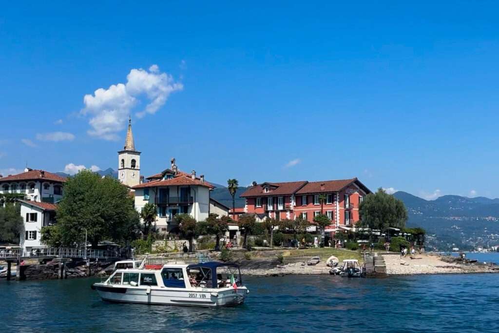
Lago Maggiore: The Reward
After the pass drama, Lago Maggiore delivers the payoff in style. The lake is enormous – it stretches across both Switzerland and Italy, with the northern Swiss section centred around Locarno and Ascona. The difference between the Alpine world you’ve spent two days driving through and the Mediterranean warmth of the lake shore is almost comic. Palm trees. Espresso. Gelato. The light sits differently here.
Locarno
Locarno is the main Swiss town on the lake – a genuine city with a compact old town, the grand Piazza Grande at its heart (one of Switzerland’s most beautiful squares, lined with pastel facades and outdoor cafés), and an extraordinary mountain backdrop that makes the combination of palm trees and Alps feel genuinely surreal. Every August, Piazza Grande hosts the Locarno Film Festival – one of the world’s oldest and most prestigious, projecting films onto a giant outdoor screen for audiences of thousands.
Walk up (or take the funicular) to the Madonna del Sasso, a Franciscan sanctuary perched above the town on a wooded cliff. The views over the lake and the rooftops of Locarno from here are some of the best in Ticino. The Castello Visconteo in the old town is a medieval fortress that now houses an archaeological museum – an hour well spent. Termali Salina Spa on the lakefront offers thermal saltwater pools and a rooftop terrace at around CHF 32 per adult – a natural end to two days of driving.
Ascona
Ascona is fifteen minutes west of Locarno along the lake and feels like it belongs in another country entirely. This was named Swiss Village of the Year 2025 – and for good reason. The lakeside promenade is lined with colourful houses, outdoor restaurants, and palm trees. The old town is a maze of narrow alleys leading back from the waterfront. The light in the late afternoon here, falling across the lake and the mountains beyond, is extraordinary.
At the beginning of the 20th century, Ascona became a gathering point for European artists, free thinkers, and intellectuals drawn by the Mediterranean light and the atmosphere. That creative energy still feels present in the galleries, the quality of the food, and the general sense of a place that takes pleasure seriously.
The Brissago Islands
A short boat ride from Ascona brings you to the Brissago Islands – two small islands on the lake with botanical gardens containing around 1,700 plant species from around the world. The islands sit at 193m above sea level, the lowest point in Switzerland. Entry to the botanical gardens costs around CHF 10 per adult. The boat from Ascona to the islands takes around 15 minutes.
The Verzasca Valley
If you have an extra day at Lago Maggiore, the Verzasca Valley is 30 minutes northeast of Locarno and one of the most beautiful valleys in Ticino. The turquoise Verzasca River runs through a narrow green gorge past the ancient double-arched Ponte dei Salti bridge at Lavertezzo (one of Switzerland’s most photographed spots) and up toward the Verzasca Dam. The dam, 220m high, is where Pierce Brosnan’s James Bond opened GoldenEye with a bungee jump in 1995 – and where you can now actually bungee jump yourself from CHF 255 per person.